- Topics
- Campaigning
- Careers
- Colleges
- Community
- Education and training
- Environment
- Equality
- Federation
- General secretary message
- Government
- Health and safety
- History
- Industrial
- International
- Law
- Members at work
- Nautilus news
- Nautilus partnerships
- Netherlands
- Open days
- Opinion
- Organising
- Podcasts from Nautilus
- Sponsored content
- Switzerland
- Technology
- Ukraine
- United Kingdom
- Welfare
The new way to survey – how uncrewed vessels could help map the world's seafloor
5 October 2021
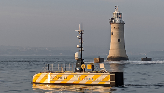
With some highly ambitious seabed mapping projects underway, it may be time to look more seriously at what uncrewed vessels have to offer in this sector, and what this means for seafaring jobs. Sarah Robinson reports
In 2007, a UK Marine Accident Investigation Branch report on a grounding off the Orkney islands revealed that some sea areas had not been properly surveyed for depth for more than 160 years.
Nautilus wrote to the UK shipping minister Jim Fitzpatrick warning of the risks posed by increasingly larger ships operating in sea areas not charted to modern standards, and also raised the concern that government funding for the civil hydrography programme had not been increased for 25 years. The minister promised a review of funding levels and an initiative to ensure that more hydrographic data, of a higher quality, could be gathered for the same costs.
Several governments have come and gone since then, but the daunting task of producing new seabed surveys for the whole of the nation's waters continues. 'Unfortunately, the UK still probably has some of the worst-mapped coastal waters in the world,' says Nautilus professional and technical officer David Appleton. 'It was disappointing that the government decided to get rid of its state-operated ETVs [emergency towing vessels] when these could have been used for surveying when not involved in maritime incidents, but the trend has been towards reliance on commercial operators in many respects.'
For UK seabed surveying, a collaborative approach is now favoured for the UK Civil Hydrography Programme (see panel 1). The Maritime & Coastguard Agency – a government body – identifies the sea areas in most need of surveying each year, and commercial contractors are hired to carry out the work.
Panel 1: UK Civil Hydrography Programme
Source: www.gov.uk
The Maritime & Coastguard Agency (MCA) has overall responsibility for the UK's hydrographic obligations under the Safety of Life at Sea Convention. The MCA manages a multi-million-pound budget to systematically survey the waters around the UK. This programme is known as the UK Civil Hydrography Programme (UK CHP). Under the UK CHP, commercial contracts are let to ensure accurate hydrographic information is gathered for updating the nation's nautical charts and publications.
The UK CHP runs a routine resurvey programme of navigationally critical shallow water areas with mobile seabed, as well as shallow water surveys – predominantly 0m to 40m water depth – and medium water surveys of 0m to 200m water depth. Sea areas currently being surveyed are as follows:
Civil Hydrography Programme 2021/2022 (Shallow)
- Barrow to Seascale
- Skerries TSS to Liverpool Bay TSS
- Dudgeon Shoal to Sheringham Shoal
Civil Hydrography Programme 2021/2022 (Medium)
- Duncansby Head to Pentland Skerries
- Sinclair's Bay to Smith's Bank
- Dogger Bank West
- Dogger Ground South
- Mermaid Shoal
Once data has passed validation, it is archived to the bathymetric database of the UK Hydrographic Office ready for inclusion in nautical charting products.
Meanwhile, it's not just the UK which is seeking to gather the information necessary to produce more accurate nautical charts. The international programme Seabed 2030 (see panel 2) is an ambitious effort to map the whole world's seafloor over the next decade. Much of the oceans are more-or-less mapped using satellite-based bathymetry (i.e. depth measurement – the marine equivalent of topography) but Seabed 2030 aims to improve on this greatly by using surface vessels and multibeam echo-sounding technology.
The scale of this project can feel overwhelming, but one company believes the answer lies in automation – and it has already brought three remote-controlled survey vessels into operation.
That company is SEA-KIT International, a British outfit based in Essex which designs, builds and operates uncrewed surface vessels (USVs). 'The company formed five years ago, and a year later produced a vessel for the Shell Ocean Discovery X Prize for remote surveying,' says director of operations Ashley Skett. 'Since I joined three years ago, we've been involved in Atlantic projects as well as in the North Sea.'
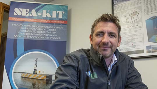
A former superyacht master and instructor, Mr Skett was one of the first USV captains in the world, and with SEA-KIT has overseen some headline-grabbing projects such as the first international commercial uncrewed transit in 2019.
Travelling from West Mersea, UK, to Ostend in Belgium, SEA-KIT's original vessel USV Maxlimer completed a challenging crossing of the Strait of Dover to deliver a 5kg box of Essex oysters to Ostend and return with a case of Belgian beer.
In the same year, SEA-KIT carried out the first uncrewed offshore pipeline inspection. Setting off from Bergen in Norway, this project was significant for its 'over-the-horizon' operation, meaning that the uncrewed vessel was out of reach of land-based communications and was operated remotely using satellite communications. The pipeline inspection was for Equinor, and the work involved launching and recovering a Kongsberg uncrewed underwater vessel from USV Maxlimer – both vessels operated from shore.
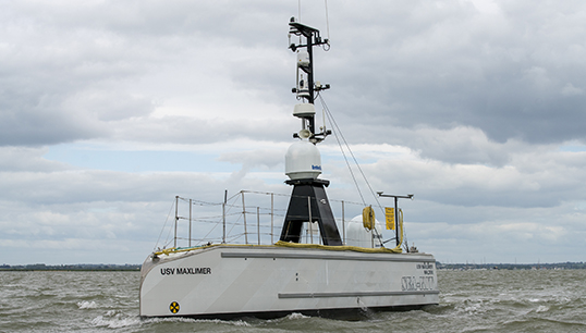
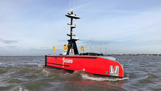
The time had come to see if the technology could contribute to the Seabed 2030 seafloor mapping project, and in 2020 SEA-KIT sent a vessel to carry out an uncrewed Atlantic survey. Again using a Kongsberg MBES device, the uncrewed SEA-KIT vessel was sent to Europe's continental margin in water depths of up to 1,362.5m.
'Our Atlantic surveying was in partnership with the European Space Agency,' says Mr Skett. 'The area has never been surveyed properly before, and we were able to prove that we could achieve precise over-the-horizon control and navigation using the kind of high-bandwidth satellite dishes that you might have for your Sky TV. We also demonstrated low-cost collection of bathymetric data with no risk to a vessel's crew – because the crew weren't onboard.'
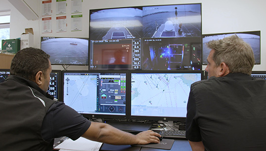
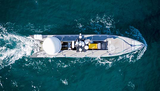
How are the SEA-KIT vessels controlled, then? 'We employ experienced STCW-qualified seafarers to operate our vessels remotely from our control room, supervised by a shipmaster. Our software puts the operators "onboard" the 12m vessel, which has two CCTV systems with nine cameras. There are also two autopilot systems onboard – for redundancy in case one goes down – and these help the vessel stay out of trouble. We also have two means of communication with the vessel: 4G, like a phone signal, and satellite.'
Much of SEA-KIT's current work is in partnership with geo-data specialist Fugro, surveying for North Sea oil and gas installations as well as offshore wind turbines. With three SEA-KIT USVs now out in the field and more under construction, the company will need to attract increasing numbers of seafarers for its Essex operating room. There will also be other opportunities around the globe as the use of USVs ramps up for projects like Seabed 2030, with operating teams handing over to each other in different time zones as the world turns and different satellites come into range of the vessel.
Panel 2: Seabed 2030
Source: www.seabed2030.org
Seabed 2030 is a collaborative project between the Nippon Foundation of Japan and the General Bathymetric Chart of the Oceans (GEBCO). It aims to bring together all available bathymetric data to produce the definitive map of the world ocean floor by 2030 and make it available to all.
The project was launched at the United Nations Ocean Conference in June 2017 and is aligned with the UN's Sustainable Development Goal #14 to conserve and sustainably use the oceans, seas and marine resources.
Knowing the depth and shape of the seafloor (bathymetry) is fundamental for understanding ocean circulation, tides, tsunami forecasting, fishing resources, sediment transport, environmental change, underwater geo-hazards, infrastructure construction and maintenance, cable and pipeline routing and much more.
Seabed 2030's aim is to map the global seafloor by 2030. From looking at global terrain models, it may appear that this has already been done. However, large areas of the seafloor in these models are based on interpolation (which is essentially an estimation based on incomplete data).
While satellite-derived bathymetry is capable of mapping undersea features in the order of several kilometres or more in spatial extent, a range of applications need bathymetric grids that resolve smaller features on the order of tens of metres in scale. It has been calculated that only 19% of the world's seafloor is currently mapped to this standard.
To contribute to the project, there is an online form on the Seabed 2030 website.
'We're offering highly-skilled seafaring jobs where people can go home at the end of the day and may not need to work unsociable hours,' says Mr Skett. 'We want people who are familiar with the rules of navigation and keeping a watch, and then we provide training on how operate a vessel remotely.
'It's definitely alien at first. You have to train yourself to act on different sources of situational awareness. You can't just look out of the window; radar is more important and there's lots of electronic data. Sometimes our onboard AI [artificial intelligence] tells you about problems and suggests a course of action, and then you make a judgement.'
There have been some concerns in the wider industry about the potential dangers of autonomous vessels to other shipping – even those USVs which are remotely operated – but SEA-KIT insists it works to the highest standards.
'We were led by the regulations in the development of our procedural and compliance practices,' notes Mr Skett – and indeed, the first ever Unmanned Marine Systems certificate was awarded to SEA-KIT by classification society Lloyd’s Register in July this year.
Elaborating on the company's safety measures, he adds: 'A crewed guard vessel accompanies our USVs in busy lanes and out of the port. Also, our vessels are built with the same equipment in two halves, and can continue if one side of the hull is damaged.
'There are no national or international training standards yet in place for what our operators do, but we hope the authorities will take note of what we are doing and put something in place. It is important that the industry as a whole remains vigilant and has a thorough approach to USV training and testing, as one incident could present a significant setback for all developers.'
Arguably, the main concerns surrounding uncrewed vessels relate to genuinely autonomous vessels: those which would operate themselves entirely using AI. It's easy to imagine why these vessels may never be welcome in busy shipping lanes, but for survey vessels painstakingly examining remote patches of the ocean, it could make sense to let the computers take over. As well as helping to complete Seabed 2030, this may be the only way to find the still-missing plane from Malaysia Airlines flight MH370.
Having already started to use AI to assist the remote operators of its USVs, SEA-KIT is well placed to attempt this next step. 'To make a Colregs-compliant fully autonomous vessel is a massive challenge, but we'd like to be the first to achieve it.'
Meanwhile, there are three British remote-controlled survey vessels out there which could surely help the UK with its relentless seafloor mapping challenge, so is SEA-KIT ready and willing? 'Conversations are being held,' smiles Ashley Skett. 'We'll see how it goes.'
Tags
More articles
What will it mean to be a seafarer?
The gender benefits of digitalisation in shipping
Simulators: 45 years of development and debate
Automation – why we need to use our heads
UK government seeks views on maritime automation
The UK government has launched a new consultation, offering seafarers the opportunity to express their views on regulation affecting autonomous vessels
